Japan/North America S2S event at Mt Elliot 23-Apr-17

As a followup to the VK/NA S2S event on 13th January UTC, Kevin AC2KL proposed a simultaneous activation event for Japan and North American SOTA stations. The timing was set for Sunday morning 23rd April in Japan and Saturday night in NA. With almost two months notice operators had plenty of time to plan their activations.

Australia is in a very similar time zone to Japan so the prospect of joining in with the event and making some summit-to-summit contacts was more than enticing. It would mean an early start so I organised a stay nearby to an easy drive-up summit allowing maximum operating time.
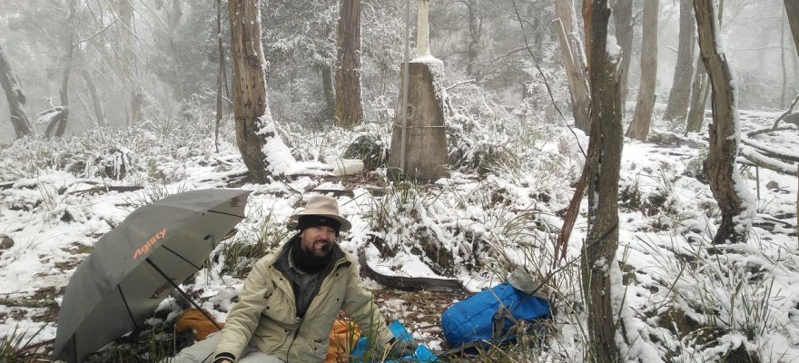
Mt Elliot

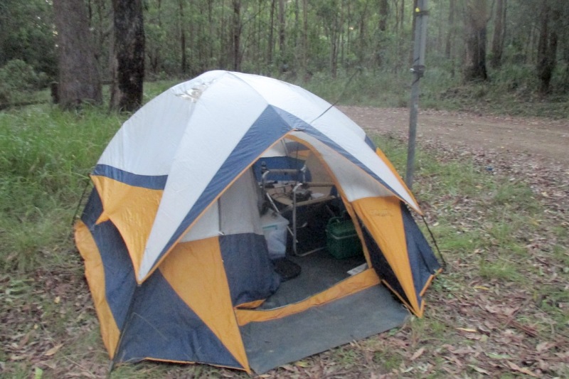
Mt Elliot, VK2/HU-093 is the summit I activate every year for New Year and the most convenient for the event. Arriving at the summit just after dawn it was a cool, clear and sunny day. Rather than operating at the usual spot I scouted around for a better location further away from the roadside power lines. RF noise on the summit is generally pretty low, but it would be critical to minimise QRM in order to work the weaker DX stations. The actual activation zone is huge. Upon checking out the lookout platform there did not seem enough room to string the antenna, a 28m long ZS6BKW horizontal inverted-Vee. Another location was found further back where there was a table and a fence post for attaching the squid pole. This was about 20m further away from the power lines than the usual table.

Antennas

As well as the ZS6BKW I wanted to use my 20m quarter wave ground plane because of its lower angle of radiation. Using a single 9m squid pole allows both antennas to be supported. An egg insulator near the top of the squid pole with a rope through it is used to raise and lower the ground plane. The squid pole was lashed to a fence post about 4m from the table. The ground plane was set up with four elevated radials but was not exactly vertical as I only had a 2m run of coax to go from the base to the table. The ZS6BKW was set up to be broadside to NA.

170423MtElliotShack

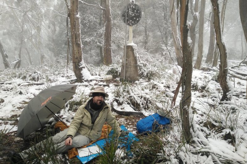
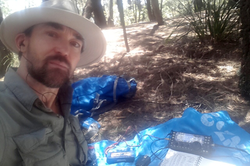
Operating position at Mt Elliot VK2/HU-093

The station consisted of a KX3 transceiver, KL-405 linear amplifier and a two-way antennas switch. The KX3 has an in-built antenna matcher so can be used on any band. The linear would only be useable on 40m, 20m and 17m where there is a good impedance match with the antennas. Only 1-2 Watts input is needed to drive the linear to full output of 50-60 Watts. It also has a receive pre-amp that can be useful for very weak signals.

Logging

To make this activation more interesting, I decided to do my logging electronically rather than on a paper log. This would be done using VK Port-a-log on the mobile phone, an application that I use religiously for spotting but have thus far ignored the logging side. This would be the trial run for the rest of my week long activating trip.

Activating

Once the station was set up the spots on SOTAwatch were checked through looking especially for NA SOTA stations. There were no audible ones so the JA stations were investigated. First summit-to-summit contact was with Hayashi JA4RQO on 15m and reports of 519 sent and 319 received. With the antenna favouring NA there was no expectation of big signals from Japan. Next S2S was on 17m with Takeshi JS1UEH and reports of 419 sent and 339 received.

Moved up the 17m band and put out a spot and started calling CQ. Rather elated when I heard Peter WA7JTM call back from Summit Mountain W7A/CS-026 in Arizona with a 449 report and I gave him 319. The power output was only 12 Watts at this stage. That surprise call was followed up with two more NA calls – both home stations: Tom NQ7R in Arizona and Larry K0RS in Colorado. These stations were also S1 so I was amazed they could hear me.

At that point the calls dried up so I started scooting around the bands checking for other SOTA activators. I worked Toru JH0CJH on 15m with 319 sent and then Jun JI1IHV on 17m with 419 sent. Signals were certainly pretty consistent. Received reports were between S1 and S3. Then I put out a spot on 20m and started calling but there were no responses at all. I noticed that the noise level was slightly elevated on 20m compared to the higher bands so there was a chance someone heard me and called but was lost in the noise.

170423MtElliotSite

Antennas and shack at Mt Elliot VK2/HU-093

It was time to give 15m a try so I spotted there and started calling. First in the log (again) was Peter WA7JTM for another S2S on a different band. Thanks Peter! Signal reports on both bands were pretty similar. That was followed by two more S2S calls from Japan: Minoru JL1NIE and Gen JS1IFK. When the calls dried up again I started chasing.

John ZL1BYZ was easy to work for the first ZL S2S on 17m and then Katsu JP3DGT and JG1GPY. Then the first of the VK activators came on. It was Andrew VK1AD at Bobbara Mtn VK2/ST-044 about 300km away and I worked him on 40m SSB. He had actually been on the higher bands for nearly an hour but I only had a very, very weak copy on him on 17m SSB so it was not QSO quality.

It was 2330z or 9:30am local and I had 11 S2S in the log so put up a posting on the facebook SOTA group in the hope of attracting some more chasers. Before UTC rollover I chased Peter VK3PF on 40m at VK4/SE-045. At that point I remembered I had brought the linear so plugged it in to work Charlie NJ7V at Humboldt Mountain W7A/AW-040 for another Arizona S2S on 17m. Signals were hanging in there at S1. In the final minute of UTC Saturday worked Wade VK1FWBD at Mt Gibraltar VK2/IL-001 on 40m SSB.

UTC Rollover

Just after UTC rollover I worked Andrew VK1AD, Wade VK1FWBD and Peter VK3PF for second S2S contacts plus some chasers on 40m SSB. Then spotted back on 17m and worked some chasers as well as Yukio JF1NDT, then chased Steve JS6TMW on 15m for his first JA-VK S2S. Some more VK activators were on air so worked Tony VK3CAT an Allen VK3ARH at Big Hill VK3/VE-059. They were on a two day hiking tour through a few summits.

Spotted again on 15m and yielded two chasers: VK6NU and JA1VRY. The DX had dried up so it was time to get to 40m and work the locals. Spotting for CW yielded 5 chasers and a S2S from Ian VK5CZ at Tothill Range VK5/SE-010. Strangely there was an SSB station calling me on the CW frequency which turned out to be an S2S from Nick VK3ANL on Mt Torbreck VK3/VN-001. Sometimes we call using CW within the SSB passband so this was quite unusual.

CW contacts had dried up so I spotted on 40m SSB and worked 12 chasers. It was packup time and just as I started there was a spot from Warren ZL2AJ at Hikurangi ZL1/MW-105 on 20m SSB. His signal was weak so I used the linear and he was the last contact and S2S for the day.

QRT

It was certainly a very successful activation with more DX S2S than I could have dreamed of. There were 25 S2S contacts including 3 NA, 9 JA, 2 ZL and 11 VK. The best band for DX was 17m with 15m coming second. 20m was pretty useless. I did compare the 20m ground plane with the ZS6BKW and found that in some cases the ground plane yielded stronger received signals. A more useful test would have been if I had one for the 17m band so it could be worth adding links into the ground plane to make it multi-band. The logging went pretty smoothly once I became familiar with a few idiocyncracies. I found I could click on a spot and have the information appear in the logging window which saved having to type in callsigns and summit references. All 55 contacts were successfully recorded and only minor editing was needed after the event. This would bode well for the rest of the trip. Time on summit was just under 5 hours.

Thank you to all the other activators, the chasers and Kevin AC2KL for initiating the event. I hope to participate in another one just like it!

Log

Time Call Frequency Mode Summit
2124 JA4RQO/4 21.063MHz CW JA/SN-077
2129 JS1UEH/1 18.091MHz CW JA/TG-107
2139 WA7JTM 18.093MHz CW W7A/CS-026
2141 NQ7R 18.093MHz CW
2142 K0RS 18.093MHz CW
2151 JH0CJH/2 21.065MHz CW JA/SO-061
2202 JI1IHV/1 18.075MHz CW JA/KN-006
2220 WA7JTM 21.061MHz CW W7A/CS-026
2225 JL1NIE/1 21.061MHz CW JA/YN-032
2230 JS1IFK 21.061MHz CW
2240 ZL1BYZ 18.0925MHz CW ZL1/WK-086
2242 JP3DGT/3 18.080MHz CW JA/HG-068
2258 JG1GPY/1 18.0817MHz CW JA/YN-043
2304 VK1AD/2 7.085MHz SSB VK2/ST-044
2308 VK2YW 7.085MHz SSB
2317 JF1IRW 18.094MHz CW
2318 KG6DX 18.094MHz CW
2320 JA1VRY 18.094MHz CW
2340 VK3PF/4 7.085MHz SSB VK4/SE-045
2358 NJ7V 18.0875MHz CW W7A/AW-040
2359 VK1FWBD/P 7.090MHz SSB VK2/IL-001
0003 VK1AD/2 7.080MHz SSB VK2/ST-044
0005 VK1FWBD/P 7.090MHz SSB VK2/IL-001
0011 VK3PF/4 7.085MHz SSB VK4/SE-045
0013 VK2YW 7.100MHz SSB
0013 VK3SQ 7.100MHz SSB
0013 VK3MCD 7.100MHz SSB
0017 VK2JDR 18.093MHz CW
0024 JA1VVH 18.093MHz CW
0029 JF1NDT/1 18.093MHz CW JA/YN-032
0034 JS6TMW/6 21.062MHz CW JA6/ON-041
0046 VK3CAT/P 7.032MHz CW VK3/VE-059
0048 VK3ARH/P 7.032MHz CW VK3/VE-059
0053 JA1VRY 21.061MHz CW
0103 VK6NU 21.061MHz CW
0108 VK7CW 7.032MHz CW
0109 VK4RF 7.032MHz CW
0112 VK4TJ 7.032MHz CW
0114 VK2MWP 7.032MHz CW
0115 VK2NP 7.032MHz CW
0117 VK5CZ 7.032MHz CW VK5/SE-010
0121 VK3ANL/P 7.032MHz SSB VK3/VN-001
0124 VK1MA 7.095MHz SSB
0125 VK4RF 7.095MHz SSB
0125 VK4HA 7.095MHz SSB
0127 VK1FWBD/P 7.095MHz SSB VK2/IL-005
0128 VK5BJE/3 7.095MHz SSB
0129 VK2NP 7.095MHz SSB
0130 VK1AT/3 7.095MHz SSB
0134 VK3ZPF 7.095MHz SSB
0136 VK3TUN/P 7.095MHz SSB
0136 VK1DW 7.095MHz SSB
0137 VK2LX 7.095MHz SSB
0138 VK7VZ 7.095MHz SSB
0143 ZL2AJ 14.295MHz SSB ZL1/MW-105

Find your VK Shire, activators!

When out activating a SOTA summit or a VKFF park you may be asked “What shire are you in“? Far from home without an encyclopædic knowledge of shire boundaries this can be difficult to answer. One may have passed a shire sign on the way to the activation, but with all the council amalgamations and name changes not even these can be relied upon.

So, a more modern method of identifying the shire is needed.
Luckily there are online resources that help identify the shire you are in.
All you need to know is your location.
Recipes for each state and territory follow (where available).

Harden Shire Yass Valley Council sign Bobborra Road between Binalong and Galong

Council signs can’t always be relied upon: Harden is merging into Hilltops Shire

NSW

Go to this web site: http://www.olg.nsw.gov.au/find-my-council
There is a text box labelled:  Address (required)
Sure, you can type in your street address.
More usefully, you can put in a GPS coordinate!
The site will then give you the name of your shire. The format accepted is latitude then comma then longitude in decimal degrees. The latitude will be a negative number for VK. Look these up with a mobile phone app such as GP Status on Android or on SOTAwatch for the summit you’re activating.

VIC

Go to this web site: https://knowyourcouncil.vic.gov.au
There is a search box that will accept your suburb. Unfortunately it will not accept a GPS coordinate. Instead use the Use my location link and when prompted ALLOW access to your location on your mobile device.

QLD

Online place name search here:
https://www.dnrm.qld.gov.au/qld/environment/land/place-names/search

Clickable overview map here:
http://www.bettercouncils.net.au/find-your-council

SA

Go to this web site: http://www.lga.sa.gov.au/councils
Enter your suburb to look up the shire.

TAS

No online lookup. Listing of shires by postcode and town name here:
http://www.lgat.tas.gov.au/webdata/resources/files/Localities_By_Council_0905.pdf

WA

Go to this web site: http://walga.asn.au/
Enter your suburb to look up the shire.

NT

No online lookup found. Rough maps here:
https://nt.gov.au/__data/assets/pdf_file/0018/206244/council-boundaries-basic-map.pdf

ACT

All one shire with code AC1.


Shire Code

Once you have the name of the shire, the three character shire code can be found in the Shire Info page here: http://www.parksnpeaks.org/showShire.php

Alternately in the spreadsheet in the Files section of the VK Shires facebook page here:
https://www.facebook.com/groups/544877775683852/files/

Look for the “vk shires” file with the .xls type. The spreadsheet has tabs for each state containing all of the shires and their three character codes. It may not be possible to read this file on a mobile device, so in that case share the load and ask the chaser to do it for you from their nice warm shack!


Spotting

Another way to find the shire code is from the ParksnPeaks site. You can self-spot for the shire you’re activating and in the process pull in all those Shires chasers. Just launch:
http://www.parksnpeaks.org/addSpot.php

Choose VK Shires as the class of activation
then in SubCat choose your state and after pressing Next you’ll be in the Shires Spot page. Choose the name of your shire from the list under Activating Shire then put in your call and QRG. Press Next and the spot will be launched into cyberspace.
You’ll end up at the VK Shires Status page with your activation listed at the top. Your shire code can be read from the details of the activation. This is probably quicker than downloading and looking up the spreadsheet!

So, go out and activate a shire the next time you activate for SOTA or VKFF!
And you might start asking chasers “What shire are you in?”

Mountain Goat on Mt Tarana 27 Jun 2016

The tenth and final summit of my “Goat or Bust” trip in the NSW Central Tablelands was Mt Tarana VK2/CT-008 located midway between Lithgow and Bathurst. There were enough SOTA activation points in this summit to put me past the magic one thousand mark so the yearning to complete this one was high.

160627MtTaranaVK2IOa

Gerard VK2IO activating Mt Tarana VK2/CT-008

Nick VK2AOH had scouted out Mt Tarana a few times as access is via private property on all sides. He’d made contact with some of the owners. When one door closed he found a way to open another one. With some skilful negotiating with one property owner he organised access and a meeting time was arranged. We met the owner who promised that as long as we tippy-toed across the adjacent property there would be no issue. So, we set upon our journey to approach the summit from the northern side. We crossed the first property, and to our great surprise, the landowner of the second property was lying in wait for us. Nick’s negotiating skills would be put to the test once again – and he came right through. There were some anxious moments, but thankfully the expedition was allowed to proceed.

160627MtTaranaBase

Nick VK2AOH at the base of the northern side of Mt Tarana

Following the fence line, up and up we went climbing into snowy ground. Through the boundary gate a wide clearing was found on the edge of a forest. We followed the clearing and it seemed to be leading us directly toward the summit. After a couple of kilometres the track looped back around and it was then apparent that its purpose was more as a firebreak. Jumping the fence we were in another forest and there was no track. We followed the GPS and it was only a few hundred metres to the summit where the trig point was easily found. It had been snowing on and off during the climb and the ground was carpeted with snow. It certainly looked a picture!

160627MtTaranaGate

Gate into the wide clearing that leads to Mt Tarana

After a few happy snaps I sent off an advisory spot to SOTAwatch giving 15 minutes notice of our activation. The ZS6BKW antenna was set up using the trig point as a vertical support for the 10m squid pole. A patch of ground that was clear of snow was picked for the radio shack. It was about 5m away from the trig point. The KX3 was set up on a ground sheet there and set for 15 Watts output.

Putting out a call on 40m CW the response was an instant pile-up. It was late on a Monday morning and not quite what I was expecting. I’m not sure whether it was the mountain or the operator who was in high demand. The mountain had only been activated once before by Nick so it was certainly a rarity. We hoped to change that and give everyone an opportunity to get this summit in their logs.

160627MtTaranaShack

Gerard VK2IO in the “shack” on Mt Tarana

Working through the callers there was Rick VK4RF and VK4HA then Ron VK3AFW. The fourth caller was Steve VK7CW and I was overjoyed making this contact as it made me an official Mountain Goat. I expressed my excitement in CW though it may have been more easily conveyed on SSB. Total radio time to achieve Goathood – less than three minutes!

A further five CW contacts were made and then I switched to SSB where more chasers were waiting. There was no need of a spot straight away as the pile-up would be overwhelming. Nev VK5WG was the first station worked on SSB. A stream of stations followed and the first SSB spot was put up 7 minutes later. Contacts on SSB continued for half an hour with 19 stations logged including ZL2ATH as a summit-to-summit. Obviously conditions were good as you don’t often make a QRP to QRP contact with New Zealand at midday on 40m!

160627MtTaranaVK2AOH

Nick VK2AOH in the “shack” at Mt Tarana

Nick jumped on the radio, or rather, swapped in his own KX3 customised just the way he likes it. He worked 40m CW for half an hour before switching to SSB. Five contacts were made using just 5 Watts so it seems that all the chasers were exhausted. Having seen a spot from Mike VK6MB I was keen to try 20m SSB.

160627MtTaranaTrig

Gerard VK2IO at Mt Tarana trig point

My KX3 was swapped in again and I started calling on 20m. Band conditions were poor and only Paul VK5PAS was worked with my signal marginal to him. After 10 minutes with no callbacks it was time to go QRT. Before shutting down Nick and I took turns leaving the activation zone and working the other on 2m FM. That way we could claim the chaser points for working the hill.

The wind was certainly a lazy one and we were very happy to end the activation and warm up on the walk back. Total time on the summit was an hour and three-quarters. The low cloud that obscured the view on the ascent had cleared so some more distant views were possible, filtered by tall trees. Light snow was still falling at times, very unusual for the middle of the day.

160627MtTaranaValleyView

Valley views on the descent from Mt Tarana

It was great to make Mountain Goat on Mt Tarana. It has taken 205 summit activations lasting 2.5 years in 25 SOTA regions over 8 countries. What a journey!

Thank you to Nick VK2AOH for company on this activation, sorting out the route and organising access to Mt Tarana.
Thanks to all the chasers for coming out of the woodwork on a weekday and making the activation a success. This was the coldest of the ten activations over the long weekend and also the most exciting for me!

Log

Date:27/Jun/2016 Summit:VK2/CT-008 (Mount Tarana) Call Used:VK2IO/P Points: 8 Bonus: 3

Time Call Band Mode Notes
01:30z VK4RF 7MHz CW
01:30z VK4HA 7MHz CW
01:31z VK3AFW 7MHz CW
01:32z VK7CW 7MHz CW YAY! Now a Mountain Goat!
01:34z VK3CAT 7MHz CW
01:36z VK3PF 7MHz CW
01:38z ZL1BYZ 7MHz CW
01:39z VK3BYD/P 7MHz CW
01:41z VK5IS 7MHz CW
01:48z VK5WG 7MHz SSB
01:49z VK3LED 7MHz SSB
01:49z VK5EE 7MHz SSB
01:50z VK2NIJ/4 7MHz SSB
01:51z VK5FANA 7MHz SSB
01:52z VK3PF 7MHz SSB
01:54z VK2WOW 7MHz SSB
01:57z VK4HNS/P 7MHz SSB
02:02z VK3GGG 7MHz SSB
02:02z VK3PMG 7MHz SSB
02:02z VK3FLCS 7MHz SSB
02:03z VK3SQ 7MHz SSB
02:03z VK2YW/M 7MHz SSB
02:06z VK2TH 7MHz SSB
02:10z ZL2ATH 7MHz SSB
02:12z VK2ZVG 7MHz SSB
02:13z VK4RF 7MHz SSB
02:13z VK4HA 7MHz SSB
02:14z VK6JON/7 7MHz SSB
02:53z VK5PAS 14MHz SSB
03:05z VK2AOH/P 144MHz FM

Lane Cove NP – 12 Apr 2016

160413LaneCoveNPsign
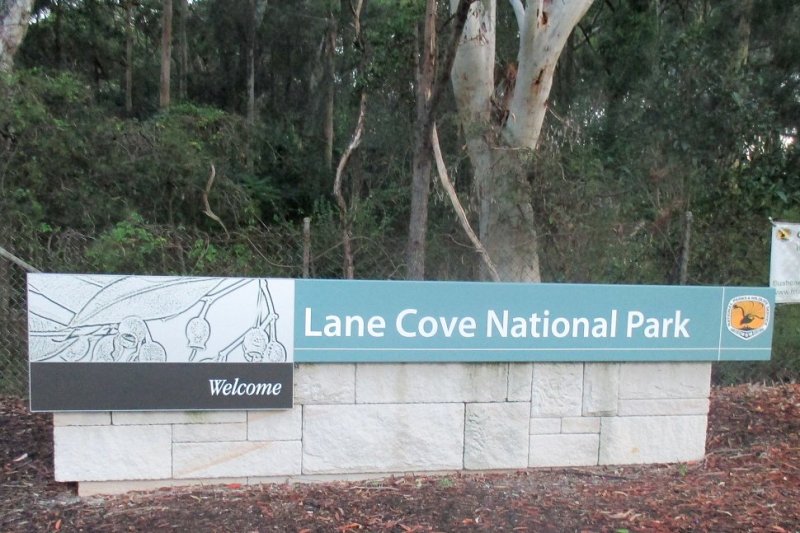
A rainy sort of day and I was in the area so decided to activate the Lane Cove National Park VKFF-0281. The park is 15km north of Sydney city and runs along the Lane Cove River through around 10 suburbs. It is usually only heard about when it catches fire and with houses backing right up to the park that does initiate a big response. The park is also along the route of the Great North Walk.

160413LaneCoveNPmapI had visited this park several times before but still had not completely explored it. This time I had to approach it in a different way being the location for a WWFF activation. From aerial maps I had identified a couple of spots around the perimeter of the park and a spot near one of the the entrances. As it turned out, one perimeter spot on Fiddens Wharf Rd could not be accessed by car as it was gated and the other one at the end of Bradfield Rd was open but restricted to service vehicles. See map here. So I ended up driving right around and going through the DeBurghs Bridge entrance to the spot near there on Riverside Drive. The road had been narrowed down to an access track and the available parking spot was not sufficiently roomy for an activation. So, I proceeded along the road and checked out an area previously unvisited called Tunks Hill picnic area. Here I found a huge and almost empty carpark with lots of green space around. This seemed ideal so I parked at (-33.780747,151.135404), locator QF56NF.

160413LaneCoveNPsiteIt had been moderately dry, but of course as I set up my antenna the heavens opened. The squid pole was lashed to the back antenna on the car and the far ends of the ZS6BKW attached to a tree and a picnic shelter. The LDG antenna tuner was set up under the car to keep it dry. One thought was that I could transfer operation to a picnic shelter without shifting the antenna, but it turned out to be too rainy and I settled in to make some contacts from the shelter of the car.

160413LaneCoveNPant
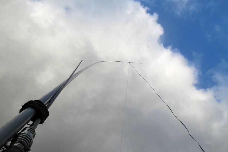
It was just after 2pm and first contact was with Warren ZL2AJ on SOTA ZL1/BP-201 on 20m. I moved to 40m and started calling and the first contact there was a park-to-park with Shane VK2TJF in the Barrington Tops at VKFF-0017. Four contacts later another P2P with David VK5KC/3 in Murray-sunset NP VKFF-0373. Propagation was pretty good and I was able to sustain contacts on 40m including with VK5. Thankfully noise was low even though I was 50m from a business premises and 200m from a main road. I was also 200m from EHT powerlines – you can see them in the aerial view.

160413LaneCoveNPtunerMy only CW contact was on 20m with Ian VK5CZ at Maurice Hill VK5/NE-049. Occupied 40m until 4:40pm during which a surprise P2P contact with Clive ZL4CJR in Fiordland NP ZLFF-0004 was made and then I switched to 20m. There were only four contacts on 20m as there was no DX opening. On 40m a further P2P, this time with Rob VK4AAC/3 in Mt Granya State Park VKFF-0767. Being close to 5pm and with the prospect of battling the Sydney traffic, I packed up in order to escape the park well ahead of the 6pm closing time. As I drove out, it was still raining lightly and I was happy to have 51 contacts in the log, especially for a Tuesday.

Equipment

  • Yaesu FT100D transceiver @ 80W
  • LDG Z100 tuner
  • ZS6BKW antenna on 9m squid pole oriented WNW-ESE

Log

ZL2AJ, VK2TJF/P, VK3MRH, VK4RF, VK4HA, VK5KC/3, VK2GAZ, VK2XXM, VK5PAS, VK3PF, VK3MEG, VK5FANA, VK3NBL, VK5FMID, VK3GGG, VK3UH, VK4DD, VK5LG, VK4ARW, VK2NP, VK2FSAV, VK2HBG, VK2AIF, VK2SK, VK2IZZ, VK2MKE, VK2FGAS, VK5KDK, VK2UBQ/M, VK2FABJ, VK2HHA, VK3MCK, VK3ZMD, VK3FD/M, VK2JAZ, VK5JK, VK5CZ, VK4WJW, ZL4CJR/P, VK2QA, VK3HSB, VK2NWB, VK3TJK, VK5GJ, VK6WE/2, VK3OY, VK4RF, VK4HA, VK6MB, VK4AAC/3, VK5PCM.

Thanks to all those who made contact!

Mt Royal NP for Field Day and SOTA 19-20 Mar 2016

A triple-header for the weekend with the John Moyle Memorial Field Day contest, WWFF at Mt Royal National Park VKFF-0362 and SOTA from two summits within the park.

VK2/HU-024 810m 4pts QF57PS in Mt Royal NP VKFF-0362

Headed first to the VK2/HU-024 summit which is just outside the southern edge of the park by a matter of metres. The activation zone to the NE is well within the park and happens to lie along Mt Royal Rd and conveniently there is a cleared space to the side of the road suitable for camping and operating from. Note that not all maps show the correct location of the park boundary or of Mt Royal Rd near the summit. SIX maps and the OzTopo GPS map V7 are OK. I activated from (-32.24473,151.28366) marked on the map with a red “X”. The park boundary and the location of the summit are also shown. There would be an elevation difference of a few metres at most between the summit and the activated location.160319VK2HU-024map

The John Moyle is a 24 hour contest starting at 0100z (noon). I arrived at about 12:45pm and walked around the area with my GPS to find the summit and check for the exact park boundary. Once confirmed I started setting up. Weather was warm with clear blue skies and no wind so a perfect day to be out and activating. A 3m metal pole at the side of the road provided a perfect mount for lashing my squid pole. I was able to raise up the base of my squid pole by 1.5m to increase the effective height of the antenna. First contact in the log was at 1:12pm, a S2S with Tony VK1VIC at Mt Ginini. Normally I use a paper log but for contests I just about always use a computer, and so it was for this contest. Well over an hour was spent working through the stations on 40m SSB and then there was a spell on CW. 40 minutes there netted 9 contacts so the pace was leisurely. I used my KX3 and had it wound up to the full 15W output. Antenna was the usual ZS6BKW inverted-Vee with the apex at nearly 10m off the ground and oriented NW-SE. To obtain this orientation, the antenna crossed the road, but with the lowest point being at about 8m it wasn’t going to be a traffic hazard!

A new three hour block had started so I could rework stations again so back to 40m SSB starting out with 3 S2S contacts. Then hunting and pecking through all the stations calling CQ for half an hour then started calling on my own frequency. The band was pretty crowded but there were still slots available. This kept me busy for another half an hour before it was time to give 20m a go. It was pretty quiet on there with only 2 stations calling from VK6. Maybe I had missed all the action. So back to 40m with the odd listen on 80m. A car full of locals stopped for a chat and find out what I was up to. The road does not go through anywhere so there was less than one car per hour going past. I mentioned my intention to scale Mt Royal and was warned about the presence of tiger snakes.

Nearing 7pm I decided to have a break from contesting and set up the tent. This was pitched next to the metal pole as the amount of free antenna feedline was limited. My operating chair was moved inside the tent and used as an operating table. After a 40 minute break I was making contacts again – still on 40m SSB. After less than 15 minutes I switched to 80m SSB where there was a lot more action. I was able to work stations in VK1, VK2, VK3 and VK4 mainly by calling CQ.

160319VK2HU-024ant

Antenna at VK2/HU-024

Operating from inside the tent was very nice as it kept off the cool breeze, and it really did cool down quite a lot after sunset. The evening was spent operating on 80m and 40m. There was a dearth of stations on CW, just weak rapid fire stations operating in another contest. I was surprised at the lack of activity. I was keen to make a 6m contact as there had been no response to earlier calls. I made a contact with the Blue Mountains radio club station VK2HZ on 80m and asked them to try 6m. They said their 6m operators were in bed – it was only 10:15pm. Still, they were happy to try for a contact on their wire antenna. Unfortunately it was a no-go as they were only just audible to me and I had a fraction of their transmitter power. it would have to be left until morning.

160319VK2HU-024night

Night time shack at VK2/HU-024

There were still plenty of stations about on 80m and a few on 40m so I kept going. Conscious of my plans for Sunday I decided to turn in at 12:45am when things became a bit quiet on the bands. It was now just CQ callers that I had worked before so a good time to cut it short. I would need all my strength and alertness for Mt Royal!

In the morning I awoke to find it already quite light. My beanie had slipped over my eyes and kept things dark and the lack of light had allowed me to sleep more than expected. It was after 7am and weather was still nice, though overcast and a little crisp. I was back on the radio at 7:45am for a short stint until 8:30am. I was able to find VK2HZ again on 80m and arrange for a 6m contact with their VHF team. This time it was successful over a distance of 183km as they were using a beam rather than a wire antenna. I also was able to just hear a station in Bathurst, but they weren’t able to hear me. The other contacts I made in the morning were on 40m and I found 80m full of ragchewers and nets.

Mt Royal VK2/HU-007 1174m 6pts QF57PT in Mt Royal NP VKFF-0362

Packing up the camp site, shack and antenna occupied an hour and then it was off to the next summit. Driving up Mt Royal road one passes through the Youngville campground area after 5km at (-32.1995,151.3094). It would make a good base if one wanted to stay a few days and operate from the park. Continuing on 3km one reaches a Y intersection with a picnic area directly ahead at (-32.1823,151.3156). At 850m elevation this is the starting point for the walk to Mt Royal VK2/HU-007. A single sheltered picnic table and a park sign marks this location.

The walk starts immediately behind the picnic table and follows the ridge line all the way to the top. There is not just one clearly defined track but a series of parallel tracks that weave in and out from each other. The gradient is steep most of the way, around 2 in 5 so it is not for the faint hearted or infirm. The elevation is 320m over 2km so its a good idea to take breaks along the way. I did not need to climb very far before entering low cloud though the visibility was still fine for following the trail. There are various rock piles along the way providing reassurance that you’re on the right track. Just after half way up there is a rocky outcrop and while it would appear attractive to skirt around it, the best way is to scramble up over it. Further up after an open area one comes to a wall of foliage with seemingly no way to get through. There is a track on the right side to duck and weave around the trees which seemed to be the best approach. I only discovered this on the way back!

The rest of the way up has quite a dense wooden canopy with some sections having very little headroom. Near the top there is a faux summit that one can skirt around to the left. One must keep going past here another few hundred metres to reach the destination. The summit holds a trig station with Royal stamped in the vane and is covered with tall spindly trees. The tracks around the trig point are quite well trodden probably due to the presence of a geocache nearby. On the trig point cairn there is a log book with a large rock sitting on it providing little in the way of disguise.

160320VK2HU-007station

Station at Mt Royal VK2/HU-007

The tree cover near the trig point is quite low so rather than set up on the trig point itself, I set up my squid pole attached to a tree nearby. The antenna wire was woven around some trees and branches and with the dropoff the ends of the antenna were only about 2m off the ground. The usual ZS6BKW was used on the 8m squid pole with the antenna apex at about 7m off the deck. It had taken 1.5 hours to reach the summit and set up so there was still half an hour left until the close of the John Moyle contest at 12 noon. Again I concentrated on 40m SSB and in the time available I was able to snag 8 more contacts. At that point the computer log was closed off and I reverted to the paper log.

At contest end I was able to start spotting on SOTAwatch and the first was for 40m CW. Conditions were certainly poor as there were only 2 contacts. After 3 summit-to-summits on SSB I went to 30m CW and made 2 more contacts, one of those being a S2S with Ron VK3AFW. Then I went through 20m CW with no contacts then chased JL1NIE unsuccessfully on 15m CW. On 20m SSB I did make four contacts. There was a successful S2S with JF1NDT/1 on 12m CW then on 15m SSB one contact with a JA and nothing on 30m SSB. Finally I ended up on 40m SSB for a bunch of contacts including two CW contacts on 7090, one a S2S with Tony VK3CAT.

160320VK2HU-007shack

Shack at Mt Royal with PC for contest logging

Once the callers ran out I stayed around for a bit on the summit before packing up and departing about 3pm. Mobile coverage on the summit was pretty good on the Telstra network though there were dropouts. For example, I missed a spot from VK2QR by 15 mins and so did not get the S2S. The signal was up to 3 bars on the phone if positioned in a certain spot, but at other times there was no data. Sitting it just off the ground the signal was coming and going.

160320VK2HU-007viewW

View looking west just down from the Mt Royal summit

The return journey was a lot quicker than the climb as the better tracks to take were more obvious and there was a lot less huffing and puffing. I did not need to descend very far before the cloud cleared allowing some visibility of the valleys below. It would certainly be a spectacular spot on a clear day.

Highlights

  • 2 SOTA summits and 1 park qualified
  • 242 contacts including 20 CW contacts
  • 21 park-to-park contacts
  • 15 summit-to-summit contacts
  • no tiger snakes!


Japan’s summits/parks for the foreign traveller/skier

Here’s a compilation of SOTA and WWFF locations in Japan accessible to the tourist. It will be updated periodically. Any contributions are welcome!

Nagano region (JA0) – Nozawa Onsen ski resort

Mt Kenashi JA/NA-107 1650m 10 pts
Access: Summer SE on route 502 from Nozawaonsen
Winter: From Nozawaonsen, (A)Nagasaka Gondola, (D)Yamabiko 2nd, ski down (2)Yamabiko-B or (3)Yamabiko-C to (C)Yamabiko, take (C)Yamabiko to top. Trail map
Also note the eastern half of the AZ is in the Joshinetsu Kogen NP (JAFF-0013).

Nagano region (JA0) – Shiga Kogen ski resort

JA/NA-069 Yakebitaiyama 2010m 10 pts – in Joshinetsu Kogen NP (JAFF-0013)
Access: Summer: footpath to summit from Yamanouchi town
Winter: Yakebitaiyama ski area, take (36) to the top. Trail map

JA/NA-045 Yokoteyama 2307m 10pts – in Joshinetsu Kogen NP (JAFF-0013)
Access: Summer: route 292 then track to summit
Winter: Yokoteyama ski area, take (67) or (68), then (69), then (70) to top. Trail map

Tokyo area (JA1) including Kanagawa

JA/TK-012 Usukiyama 842m 4 points

Access: via 2km track from Hinohara Hwy 33 past Usuki shrine.
Closest station Musashi Itsukaichi on the Itsukaichi line.

JA/KN-022 Shiroyama 375m 1 point

Access: Take one train from the major stationShinjuku in Tokyo until the end of the Keio Sagamihara line at Hashimoto (station KO45). Then take the Hashimoto 01 bus for Mikage to stop 14 at the base of the mountain called Tsukuiko Kanko Center mae (35.58643N, 139.280824E). Timetable and route is here. The summit is in the Kanagawa Kenritsu Tsukuikoshiroyama Park. Once starting the climb, there are maps available en-route. Summit at (35.5831N, 139.2787E) PM95PN. Blog by VK2IO.

JA/KN-017 Bukkasan 747m 4 points

Access: Take Odakyu line from Shinjuku up to Hon-Atsugi station – about 1.5 hours. From Hon-Atsugi go to through the north exit to bus stand 5 and take the bus for Miyagase 厚20 宮ヶ瀬行 市立病院前(本厚木駅発) Route name 厚木20 Atsugi 20 and get off at Bukkasan Tozanguchi 仏果山登山口. Alternatively take  a bus for Miyagase 厚21 宮ヶ瀬行 市内(本厚木駅発) route name Atsugi 21 from the same bus stand. This bus also stops at Bukkasan Tozanguchi. The walk to the summit takes 1.5 hours. Blog by JH0CJH. Track to summit is here.

JA/KN-006 Ooyama 1252m 8 points – in Tanzawa-Oyama Q-NP (JAFF-0050)

Access: Take Odakyu line from Shinjuku to Isehara station. From Isehara North gate take bus platform number 4. Take a bus for Ooyama Cable 伊10 大山ケーブル行 route number Isehara 10. From terminal station, take cable car to half way point then continue hiking. This mountain is famous for foreigners so you may find some English natives. Ask for “Ooyama Cable Car?” before boarding the bus. Summit at (35.440799713135, 139.23120117188).
Notes: Good location, very popular so huge number of people. Best to operate on the west side near microwave antenna tower otherwise it may become
difficult around lunch time.

Meiji Memorial Forest Takao Q-NP (JAFF-0049)

Blogs by JA1JCF and VK3ARR.

Chichibu-Tama-Kai National Park (JAFF-0005)

Mitakesan lies 3 or 4km northeast of Oodakesan JA/TK-007

Shizuoka area (JA2)

JA/SO-099 Takanesan 504m 2 points

Access: Route 52 north off Tomei Expwy then route 75 west then left after 600m up to summit. Parking inside activation zone.

JA/SO-120 307m 1 point

Access: off Shimizu Nihondaira Pkwy, Komagoe then walk up 200m. Blog by VK2IO.

Yamagata prefecture (JA7)

Zao quasi-National Park (JAFF-0044)

Access: The Zao Onsen skiing area is within the National Park. Area map is here and the park is marked in purple on p.10 lower right.
Blog by JA7IC.

Akita prefecture (JA7)

JA/AT-001 Komagatake (Onamedake) 1637m, 10 points – in Towada-Hachimantai NP (JAFF-0027)

Access: From Tazawako station take Akita Komagatake line bus to the end at “8th Stage of Akita Komagatake”. Walk 1.5 hrs to summit. Open between June 1 and October 31.

Hokkaido (JA8)

JA8/SB-005 Nisekoannupuri 1308m, 8 points

Access: In winter this summit can be accessed from the top chairlift at the Niseko Annapuri ski resort. This lift (and lower lifts) are only open during favourable weather and for a few hours around the middle of the day. Take Jumbo Pair lift #4 and go through Gate 2 and climb up to the south peak. Then walk north a further 400m to Annupuri. No trees here so bring your own squid pole. The AZ is within JAFF-0036 Niseko-Shakotan-Otaru Kaigan Quasi-NP.


Additional resources

Cluster in Japan for posting local activations: http://qrv.jp/

Beacon monitor for daily  band conditions: http://ayoko.net/faros/

Japan Century Cities awards program: JCC

WWFF logs should be sent to logs@wff-dl.de as there is no local coordinator. 44 contacts need to be made as there are no JAFF awards yet.

JAFF park maps tend to be in Japanese. As a guide, use the Protected Planet site and search for the park to find a map in English with the park boundary.

Thanks for contributions from: Gou JA1SWI, Toru JH0CJH, Nobi JA1JCF, Andrew VK3ARR

SOTA first activation of Udoyama JA/SO-120 – 14 Feb 2016

As part of my 2016 Japan trip I travelled to Shizuoka, 180km and about 3 hours drive south of Tokyo. I activated Udoyama JA/SO-120 for the first time with help from my friends Yoshi JG1VOZ and Hiro JA2LXT. This summlt is more accessible to Shizuoka city than Takanesan JA/SO-099 previously considered. Near JA/SO-120 there is a peak and lookout with a TV tower called Nihondaira Prefectural Natural Park and we went there first only to find ourselves 300m away from the real peak. I dare say it would not have been in the Activation Zone either. One must continue on the Shimizu Nihondaira Parkway to (34.9749, 138.4695) and then drive up a rough track 300m and then walk up a steep muddy track 200m to the summit with some bush bashing. The summit is marked with a tag saying 307m and is at (34.973099, 138.4697), locator PM94FX.

160214UdoyamaShack

Shack on Udoyama JA/SO-120

The summit is overgrown with lots of trees. I used a linked ground plane and threw the end of the antenna over a tree. On 20m I made four VK/ZL SSB contacts and three VK on CW using the callsign JR2YFM/2. On 40m CW I made four local contacts. Ended up with more contacts than at Shiroyama JA/KN-022 in less time. I was able to stay on 3 Watts throughout the one hour activation. One contact was a S2S with Takeshi JS1UEH at JA/IB-006 on 40m – my first for JA. This was also a first activation of Udoyama JA/SO-120.

160214UdoyamaRig

Rig and log book on Udoyama JA/SO-120

Thank you for all the contacts and for those that chased. One discovery via SOTAwatch was that 7032 is used for RTTY in Japan. When 40m is open to JA from VK it may be better to stay below 7032.

There is a short video from this activation here.

My first SOTA activation in Japan – Shiroyama 13 Feb 2016

The first SOTA summit I climbed during my visit to Japan was Shiroyama JA/KN-022. This summit is on the western outskirts of Tokyo and just over the border into Kanagawa prefecture. And climb it was as the bus drops you off a little above sea level. The summit is at 375m elevation rising up steeply from the flatlands of Tokyo.

Public transport to the summit is very convenient. Take one train from the major station Shinjuku in Tokyo until the end of the Keio Sagamihara line at Hashimoto (station KO45). Then take the Hashimoto 01 bus for Mikage to stop 14 at the base of the mountain called Tsukuiko Kanko Center mae (35.58643N, 139.280824E). Timetable and route is here. Once starting the climb, there are maps available en-route.

Near the top there is a faux-peak with a small shrine. One then walks down a little and up again to the real peak which has a cleared area at the top (35.5831N, 139.2787E). I set up just to the side of this clearing.

160213ShiroyamaShack

My station consisted of a linked ground plane antenna that I had made that day after scouring Akihabara for parts. It had links for 40m, 20m, 15m and 10m. The radials were designed for 20m. A tree provided the top support for the vertical section of the ground plane.

The radio used was the KX3 on internal AA alkaline batteries.With such a small power source the radio could only be used QRPp and I started out at 3 Watts. With the 6m/10m SOTA challenge in its last day, I set up on 10m at first.On SSB I was rewarded with 5 contacts: JJ1SWI/1, VK4RF, VK4HA, JA1JCF and 7K1WRK/1. I tried CW too but made no contacts in that mode. Callsign used was JR2YFM/1. QTH locator: PM95pn.

Lowering the vertical, I joined up the first pair of wires and was then on 15m. On that band I made one contact with JJ1SWI/1 again. The radio was starting to shut down during transmit occasionally so I had dropped the power to 2 Watts. Seemed unusual to only have one call on 15m, however, there may have been no propagation. JJ1SWI is local to Tokyo so it was a ground wave contact.

Next was 40m and two more links were joined in the antenna. On this band there was another call from JJ1SWI/1 at about the same strength as on the other two bands. I had reduced my power down to 1 Watt at this stage.

For the final change it was to 20m CW and after dropping the antenna and removing a link I was rewarded with a call from Rick VK4RF and his alter-ego VK4HA. Sigs received on this band were 58 from Rick so quite a bit stronger than on 10m. The difference was that I worked Rick using 3W on 10m but only 1W on 20m.

With little battery left and the light fading fast I had to pack up quickly and drop down the mountain. It took about 30 mins to climb to the top and about 20 mins to descend. With a 3 minute wait for the bus I was on my way back to Tokyo. Allow 90 mins to get to Shinjuku station.

So, a very successful activation. Although I made 4 contacts on CW, there were only 3 unique stations so I am yet to qualify on CW. I well and truly qualified on SSB. This is a very easy one to activate if you are in Tokyo as the public transport is so convenient. The only difficult thing is the climb. Remarkably, there is no QRM at the top of the mountain. Nice views of the dam and countryside below too.

Mt Solitary activation 30 Dec 2015

The SOTA peak at Mt Solitary VK2/CT-056 in the Blue Mountains National Park VKFF-0041 had been on my to-do list most of 2015. I’d resolved not to attempt it in winter to ensure adequate daylight and to make it a comfortable climb. Last time (and first time) I did this walk I ended up having to walk back in the dark which was “different” but not as much fun. I’d hoped to tackle this one with Phil VK2JDL, but as it turned out he was busy on the last possible day of the year it could be done.

151230MtSolitaryMap

Walking path to Mt Solitary starting at the Golden Staircase

The starting point for the walk is at the top of the Golden Staircase (-33.734348, 150.28237) at elevation 958m which can be found on Glen Raphael Drive along Narrow Neck just west of Katoomba. Descend the Golden Staircase (about 800m) passing Botleys Lookout until the Federal Pass circuit track is reached. Turn right (south) and gently descend by 300m elevation reaching the 4.3km mark. From then on it is an ascent of 300m over 1.8km including a lot of hard climbing and scrambling to reach the summit (-33.7797, 150.3079) QF56DF at elevation 960m. I budgeted two to two and a half hours to do the 6.1km walk, but walking quickly without stopping to take any photos it took one and a half hours. The National Parks site provides all route details and it is also well covered on Wild Walks. The alternative and longer route is to start at Scenic World, descend the Furber Steps and join the Federal Pass circuit there. It adds another 3 km onto the trip. Some of that can be saved by descending using the Scenic Railway instead of the Furber Steps. Details of this alternative can also be found on Wild Walks.

151230MtSolitaryProfile

Elevation profile from Golden Staircase (958m) to Mt Solitary (960m) with minimum elevation of 658m

The summit itself is quite a flat area covered with tall trees. This gives a large activation zone and there are plenty of places to put up an antenna. The main consideration is making sure it is clear overhead so that the antenna wire is not obstructed. I found a convenient stump to use as a support for the squid pole. Knowing the difficulty of the walk, I brought along a lightweight 8m pole and removed all extraneous items from my backpack. The pole was able to be inserted into a pocket on the backpack so I had both hands free – and this turned out to be essential during the climb. Conveniently, I had arrived and set up 15 minutes before UTC rollover whereas my alert was for thirty minutes past. There were SOTA stations already active so plenty of scope for summit-to-summit contacts.

This slideshow requires JavaScript.

The first object was to work all the activators and I managed four before rollover – all on 40m. Then after rollover hunted for the same activators again. I was calling VK3HRA on his spotted frequency 7032 CW when Nick VK2AOH called me. Somehow I had missed Allen. A whole bunch of activators were spotting on 10m so I went there to look for them. I did manage one S2S with Andrew VK1AD at Mt Taylor in Canberra. All the other summits were too far for ground wave and too close for sky wave. Then I put my first spot up on 10m SSB and that attracted a couple of contacts in VK5, one in VK4 and one in Sydney from VK2BEN. After an hour on 10m I spotted on 6m SSB and attracted 2 stations from Sydney – Cliff VK2NP and VK2BEN again. I had heard Andrew VK1AD work a VK4 at good strength on 6m but Andrew’s signal faded quickly. Unfortunately I was not able to work the VK4. During some free time I put up a “selfie” of my activation on social media. This attracted a certain amount of attention and comment and made for a talking point during contacts. At some stage I’d like to try sending pictures via SSTV from the summit as thus far I’ve only received SSTV from summits in the shack.

151230MtSolitaryShack

Shack and operator on Mt Solitary

After 20 minutes a spot came up on 40m so I abandoned 6m and chased a bunch of activators (VK3MCD, VK2QR, VK1VIC, VK3VTH). I spotted on 10m SSB again and started calling then a spot came up for Greg VK2GSB at VK2/HU-094 who was doing his first activation near Port Stephens in Myall Lakes NP. I was the first contact in his log and it must have been a surprise as it was a summit-to-summit as well as a park-to-park contact.

This slideshow requires JavaScript.

Back on 10m I made a bunch more contacts over the next hour with the occasional excursion to other bands to work other summit stations. 10m was in good shape as I was able to make contact with chasers in Melbourne at good strength. This represented quite short skip conditions on this band. Next was a go at 10m CW and this was rewarded with 3 contacts from Melbourne stations with excellent reports.

After half an hour on 10m CW it was late enough to give 40m CW a try too and five contacts were made. Then I moved to 40m SSB and filled a page full of contacts over the next hour. This included two S2S contacts. The sun had moved around and now my spot under the trees was in full sun so the shack was relocated a few metres for complete shade.

This slideshow requires JavaScript.

With one hour to go to my planned departure time of 6pm I went back to 10m SSB and started calling there. One contact was made with VK2FJPR in Newcastle who I had worked on 40m and mentioned a possibility of 10m. He was pretty surprised to be able to make a contact and we exchanged 5×3 reports both ways. The good propagation to Melbourne had gone and no other 10m contacts were made. I contacted Rod VK2TWR to try for a 6m contact, but he wasn’t able to hear me so we made it on 40m instead.

A spot by Lewis VK6FLEW on 40m attracted a QSY, but Lewis was operating on 7.144 and the afternoon net on 7.146 prevented any copy. It was then time to close down after operating for 7 hours. My 4200 mAh battery was just about exhausted and the KX3 kept switching off. It was a longer activation than expected and I was restless to complete the return journey. Last time I had done it mostly in the dark and had not planned to do that again this time, after all I had photos to take! One of the concessions when reducing weight was to eliminate cameras from my backpack. The DSLR weighs around 3kg and had to go. I even rejected the compact camera with the intention of relying on the rarely used mobile phone camera. That’s the mark of a lightweight activation!

151230MtSolitaryCampsite

One of the many camp sites along the Federal Pass

My Android-based mobile phone has an aftermarket high capacity battery, but before I started the return walk it was down to around 30% capacity. During the day I was running RRT, ParksnPeaks and Port-a-Log apps at various times, and usually multiple simultaneously. This no doubt would have required additional internet traffic (and therefore battery consumption). Luckily mobile phone coverage was good with few dropouts. For the first time on an activation I had used RunKeeper to record my progress on the walk so the GPS was running during this time. On the return walk I also used RunKeeper and so was able to obtain an elevation profile for the day’s outing.

151230MtSolitary3Sisters

Glimpse of the Three Sisters through the trees

The return walk was a lot more difficult than the morning walk even though I had had plenty of recovery time. I doubt the endorphins were flowing like they are when you’re striving to reach a summit. Luckily I had plenty of rests to take photos. Descending from Mt Solitary I ran into some people who were about to launch a toy drone. As I continued further the drone appeared in the skies above along with the characteristic buzz. It seemed to follow me for quite a way and my thoughts were that the country was quite inhospitable in the event that a drone recovery was required, though it seems that was not necessary. I had bypassed the sidetrip to the “Ruined Castle” on the way in and did the same on the way out. Its another steep climb and would add time to the trip.

This slideshow requires JavaScript.

The most difficult part of the trip was the return climb up The Golden Staircase. The track is well formed unlike the last section up Mt Solitary, but it is so steep with metal railings and for such a long distance that it is pretty difficult at the end of a long day with not much left in the tank. There are some nice glimpses of the Three Sisters along the way, especially from Botleys Lookout near the top.

This slideshow requires JavaScript.

I arrived back at the carpark just as the sun was setting so timing was perfect. After taking time to watch the sun go down, take photos and rehydrate, I did some chasing for the EU activators. Even on CW it was not possible to work any of them due to low signal strength so after half an hour I was on my way.

151230MtSolitarySunset

Greeted by a stunning sunset climbing to the top of the Golden Staircase

Highlights

  • Making it to (and from) the summit
  • Stunning views of the Jamison Valley and the Three Sisters
  • Fabulous sunny weather all day with light breezes
  • 67 contacts on 40m, 30m, 10m, 6m including 9 CW  on 40m, 10m
  • 17 summit-to-summits
  • 13 park-to-parks
  • First documented activation of this summit
  • 18 contacts on 10m/6m including JA DX

Equipment

  • Elecraft KX3 transceiver
  • One LiFePO4 4200 mAh battery
  • uniHAM UNI-730A CW paddle
  • ZS6BKW inverted-Vee doublet (28m long)
  • 8m lightweight mast
  • Earbuds stereo headphone

Log

Many thanks to the following stations for making contact:
VK3HRA/P VK1VIC/2 VK1AD/P VK3PF/P VK2YK VK1VIC/2 VK3PF/P VK1AD/P VK4RF VK4HA VK1DI/P VK2AOH VK1AD/P VK5WG VK4MNM VK5NRG VK2BEN VK2NP VK2BEN VK3MCD/2 VK2QR/P VK1VIC/2 VK3VTH/5 VK2GSB/P JH7RTQ VK7CW JL1RUC VK7FRKL VK1MA/3 VK3PF/P VK3YUN VK3HRA/P VK3ZPF VK3CAT VK3AFW VK3ANL VK2AOH VK1EM VK3PF/M VK3BYD VK1CT VK3UH VK1AT VK3FQSO VK3YAR VK3ES VK3NBL VK3LED VK2PHA VK1DW VK3AWG VK3AV VK2NN VK3CRG VK2YK VK3ARR/P VK2VW VK2GAZ VK3DAC VK2ZZM VK2FJPR VK2JDC VK2YW VK3HRA/P VK3PMG VK2FJPR VK2TWR

Leg recovery after the walk took a few days.
Will I activate this one again?
You betcha!

Cattai NP for VKFF Activation Weekend 29-Nov-2015

The second day of the VKFF Activation Weekend I headed to Cattai National Park VKFF-0092 on the northern outskirts of the Sydney metropolitan area. The park lies on the southern bank of the Hawkesbury River in the suburb of Cattai. The park includes a popular camping area as well as outdoor facilities and a historic homestead (-33.558878, 150.892197).

151129CattaiMapMy plan was to operate in the park all day with a late morning start after a late night the evening before. This went totally to plan. I arrived at the park (-33.547513, 150.899308) off Caddie Rd via Wisemans Ferry Rd at around 10:15am, purchased an entry ticket from the machine and continued deeper into the park. After passing some shelters I entered the camping zone (-33.553787, 150.892245) for a sticky beak. There were quite a lot of campers set up there and I decided the best place for me was away from there back at the shelters several hundred metres away. None of the covered shelters were being used so I set up at the very first one (-33.558514, 150.890148) locator QF56KK nearest to the wharf. This was ideal for setting up an antenna as there are large trees on opposite sides spaced about 20m on either side. The squid pole itself was mounted against a large wooden support used for the shelter, the width of a medium size tree. The ZS6BKW antenna was used for this activation.

This slideshow requires JavaScript.

The KX3 was set up on a table under the shelter and I also had the FT100D as a backup but it wasn’t needed. First contact in the log was at 10:45am with Tony VK1VIC at Farrer Ridge Nature Reserve in the ACT. It seemed as though propagation on 40m would be reasonable. After this quick contact I took some time to set up the station and antenna properly for the day. Then I settled in for a session on 40m, hunting down any other park activators that came up which occupied the next half an hour. A further eight parks were worked and I was then operating on my own 40m frequency. There were plenty of chasers as far afield as VK5 and short skip was working too.

Adam VK2YK was activating Castle Hill lookout in Townsville and I was able to work him on 15m for my first SOTA contact of the day. Back to 40m and a stint on CW yielded four contacts. After that it was back to hunting for a bit and then I spotted on 15m SSB. After 15 mins making no contacts I moved on to 20m SSB for 15 mins then 20m CW for 15 mins but there were no contacts to be had. I had a break of 10 minutes for lunch until more activators started up. After an hour without a contact I stayed on 40m for an hour and there were seven more parks worked as well as two SOTA stations. The drought had broken. I self spotted on 40m SSB again and made some more contacts from that.

This slideshow requires JavaScript.

When things became quiet on 40m I went up to 10m and found some contest stations to work on CW. They were mostly sending lightning fast and with my 10W I was able to work Japan, Vietnam and Hong Kong. All I had to do was send my normal signal report and my CQ zone of 30. Switching to 15m I found stations operating in the same CQ World-Wide DX CW contest and was able to crack Russia, Tuvalu and Brazil as well as Japan. It was one way of racking up contacts towards my goal of 44 uniques.

This slideshow requires JavaScript.

After an hour in the contest there were more parks to work so it was back to 40m. Then I took a break to take photos for half an hour, visited the wharf. Upon return I self spotted on 7.144 announcing last calls and that seemed to trigger a run of hunters which kept me busy for twenty minutes. When the callers ran out I chased John VK6NU on 20m in Wandoo NP and rounded things out with a couple more parks in VK5. By then it was 5:45pm and I was mindful of the sign announcing gate closure at 6pm so it was a hurried closedown. I drove out of through the gate, parked and then walked back in. Kangaroos were clustered on the grassy areas and I also wanted to check the signage on the office building. It was unattended and indicated the park ranger is stationed at another site, probably the much larger Scheyville National Park.

Statistics

  • 63 contacts (12 CW)
  • 31 park-to-park contacts
  • 3 SOTA contacts
  • 8 DX/contest contacts
  • Bands: 40m, 20m, 15m, 10m
  • 7 hours operating time

What a great weekend the inaugural VKFF Activation Weekend turned out to be. I’m looking forward to next year. Thanks for all the contacts:
VK1VIC/P,VK1DI/P,VK5FANA/P,VK2NP/M,VK4AAC/5,VK5PAS/P,VK8AR/P,VK3VTH/P,VK1AT/3,VK3PMG/P,VK2VW,VK3OF,VK2GAZ,VK4RF,VK4HA,VK5UK/3,VK5KPR/P,VK5ZGY/P,VK2YK/4,VK5HCF/P,VK3HRA,VK4RF,VK4HA,VK2YW,VK1VIC/P,VK3HN/P,VK1MA,VK1DI/P,VK5HCF/P,VK5EE/P,VK5HSX/2,VK1DA/2,VK1VIC/P,VK3TKK/P,VK3PF/P,VK3YAR,VK3DPG,VK2QR,VK5PAS/P,JA3YBK,XV9NPS,VR2XAN,VK3VTH/P,RT0C,7J1YAJ,T2XX,PT2CM,JR1MEG/1,VK3TST/P,VK3PF/P,VK3KAI/P,VK2HHA,VK3UH,VK7CW,VK3DBP,VK5BJE,VK5AV,VK5FGRY,VK5PL/P,VK5NFT,VK6NU/P,VK5LOL/P,VK5PET/P.